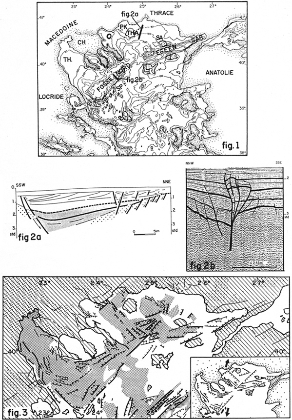
Fig. 1: Simplified bathymetric map of the north Aegean sea; the lettering refers to geographic terms: TH, Thermaikos; 0, Orfanou; P. K., Prinou-Kavala; THA, Thasos; SA, Samothrace; SP, Sporades; L, Limnos; I, Imbros; SAR, Saros; LO, Locride; MA, Macedoine; CH, Chalcidique; THR, Thrace; AN, Anatolie. Locations of seismic sections of Figure 2 are shown.
Fig. 2: Examples of typical seismic sections across (a) a distensive basin east of Thasos, (b) one of the depressions of the N.A. T. (western sector); note on (a) the characteristics of the seismic sequence, including the classic M essinian evaporites reflectors; on (b) a well expressed flower structure.
Fig. 3: Structural sketch of the Northern Aegean Sea. In hatchures, Pre-Neogene onshore outcrops; dotted, main upper Miocene to recent depocenters (onshore and offshore); only structural lineaments with vertical offset upper than 0.3 s.t.d. are shown; in thick black, faults zones with offset upper than 1 s.t.d.; in thin black, faults zones between 0.3 and 1 s.t.d. of offset. In insert, general structural interpretation of the area in the frame of a dextral strike-slip motion and associated extension.
[from Martin and Mascle (1989)].
|